

- Walk2014
- LearnHistory • Heritage

- TrailMaps • Guides


- ExploreDestinations • Tours • Routes
- NewsCurrent • Archived
News about Friends of Laura Secord

Videos
Print and Online Articles
Blogs
Newsletters - EventsUpcoming • Current • Past
Events

- SupportJoin • Donate • Volunteer
Help support Friends of Laura Secord!


|
Add this location to my itinerary |
Laura's CrossingOff Power Glen Rd, along the Laura Secord Legacy Trail Ontario
|
TRIP CLIP AUDIO - LAURA'S CROSSING
Click to play or download LAURA'S CROSSING TripClip (mp3 format).


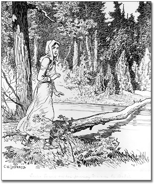
Left: An artist's rendition of Twenty Mile Creek during the War of 1812 period (painting by J. W. Cotton). Right: Laura Secord is thought to have crossed the Twenty Mile Creek on a fallen log (drawing by C. W. Jefferys).
Photos: [Toronto Public Library; Government of Ontario Art Collection].
|
|
SECORD SIGNIFICANCELaura’s Crossing is a short section of Twelve Mile Creek where Laura Secord is believed to have made her way across the rain-swollen stream on a fallen log to warn the British forces of an impending American invasion. There are, of course, many issues that remain unresolved about her walk, including the details of her route, and the location of her creek crossing is no exception. But over the past several years, Brock University historian and geographer Professor Alun Hughes marshalled evidence from written sources, historic maps, and the actual topography and landscape of the area to create a compelling case for where Laura’s crossing likely took place.
|
GENERAL INFORMATION
No one is absolutely certain of the exact spot where Laura Secord struggled across Twelve Mile Creek on a fallen log in her quest to warn the British of an impending American invasion. But most bets are on a meandering stretch of the historic watercourse that's now within the borders of Short Hills Provincial Park.
Laura Secord actually crossed Twelve Mile Creek twice during her epic trek. From her home in Queenston, she would likely have followed the main route of the old Iroquois Trail, now Queenston Street, York Road, and St. Paul Street, into Shipmans Corners, which was little more than a creekside village at the time.
On reaching modern-day Ontario Street, she would have cut to the left and descended into the steep valley of the Twelve Mile Creek, crossing it by means of a low level bridge that was in place in that era. There is no evidence that the wooden bridge at Shipman’s Corners was destroyed in the War of 1812, so Laura’s first crossing was probably not much of a challenge. A wooden swing bridge was erected there but it was later replaced with a steel truss bridge now devoted to pedestrians and cyclists at the foot of St. Paul’s Crescent.
After crossing the creek Laura faced two choices. She could continue up the valley of the Twelve Mile Creek, or she could ascend the slope on the other side and follow Pelham Road. Alun Hughes believed the latter is likely what she did. Nowadays the lower part of the Twelve Mile Creek is fast-flowing, at times near a torrent, thanks to the two DeCew Falls Generating Stations at Power Glen, opened in 1898 and 1947. But in 1813 it was a small, meandering stream, flowing through what was probably a very damp flood plain. To venture up the valley would not have been a wise choice. She would probably have chosen to avoid the low wet areas. Hughes believes she would have planned in advance to make a more circuitous approach from the west, to avoid being overtaken by the American troops on their way to attack FitzGibbon.
There was no village of Power Glen in 1813. There was only a grist mill and a saw mill, owned by Peter Thomas, down in the valley alongside the Twelve Mile Creek. An access road led from Pelham Road to the mills, and this is what Laura may have followed. Apparently this road led to a bridge over the creek, which Laura had planned to cross to get to the DeCew House. But the bridge had been washed out by recent rains, and, in Laura's own words, she had "to cross over an old fallen tree”.
But where exactly did she actually cross? An early photograph from the Jubilee History of Thorold, published in 1897-8, may provide some evidence. Captioned "Present appearance of the spot where Laura Secord crossed the Twelve Mile Creek on her way to warn FitzGibbon," the staging of the photo by local historians presumably drew on the recollections of those more familiar with Laura’s original story. The configuration of land and sky in the photograph points strongly to a location close to the access road for the Peter Thomas mill, where Twelve Mile Creek turn sharply to the south. Before this point, the Escarpment bluffs on the eastern shore are precipitously steep and virtually impassable, but the steep hogsback along the western shore of the creek dwindles away at this location. Though still a strenuous challenge, it would have been much easier to cross the creek and and climb the escarpment at that location.
After she crossed the Twelve Mile Creek and proceeded across the small flat area we now call ‘Laura’s Meadow’, Laura climbed the wooded "mountain" (the Niagara Escarpment) into DeCew's Field, where she encountered the group of Kanesetake Mohawk warriors who took her to see Lt. James FitzGibbon.
To commemorate the bicentennial of Laura’s trek, and to provide the public with a means of crossing the creek without getting their feet wet, the Friends of Laura Secord worked to get a pedestrian bridge designed and built in this auspicious location. The Bridge at Laura’s Crossing was installed in mid-May 2013, officially opened on the first of June, and [will be] formally dedicated on 22 June in the presence of Mrs. Laureen Harper, wife of Prime Minister Steven Harper – two hundred years to the day after Laura Secord’s momentous journey.
Hours of Operation
Open Access
DIRECTIONS
Crossing # 1 - See Map
From QEW:
1. Note the QEW exit number by which you enter the highway. The numbers ascend as you get closer to Toronto.
2. Drive along the QEW toward exit 42, for Ontario Street/Regional Road 42
3 . After taking the exit turn onto Ontario St South/Regional Rd 42 (signs for Regional Road 42 S/Ontario Street)
4. Drive 3.3 km then turn right onto St Paul St W (signs for Regional Road 81/Saint Paul Street)
5. Turn left onto Bellevue Terrace then take the 1st left onto St Paul Crescent
The bridge is located at the north end of St. Paul Crescent
Crossing # 2 - See Map
From QEW:
1. Note the QEW exit number by which you enter the highway. The numbers ascend as you get closer to Toronto.
2. Drive along the QEW toward the exit onto the ON-406 S toward Thorold/Welland/Port Colborne
3. After taking the exit drive 3.9 km then take the Regional Road 77 W/Fourth Avenue W exit
4. Merge onto Fourth Ave/Regional Rd 77
5. Turn left onto Louth St/Regional Rd 72 (signs for Regional Road 72/Louth Street)
6. Continue to follow Louth St which then becomes Pelham Rd.
7. After 4.5 km turn left onto Power Glen
The approximate area where Laura crossed the Twelve Mile Creek is located about 200 metres south of the southern curve of Power Glen Rd. The Laura Secord Legacy Trail, constructed in 2011-13, includes a bridge in the area she might have crossed.
Further Information
Hughes, A. (2012). Following in Laura's Footsteps. See http://www.niagaragreenbelt.com/pdfs/Following%20in%20Laura's%20Footsteps.pdf
Share this post


Address
Off Power Glen Rd, along the Laura Secord Legacy TrailMunicipality St. Catharines
GPS Co-ordinates
Longitude -79.269537


