

- Walk2014
- LearnHistory • Heritage

- TrailMaps • Guides


- ExploreDestinations • Tours • Routes
- NewsCurrent • Archived
News about Friends of Laura Secord

Videos
Print and Online Articles
Blogs
Newsletters - EventsUpcoming • Current • Past
Events

- SupportJoin • Donate • Volunteer
Help support Friends of Laura Secord!


|
Add this location to my itinerary |
Shipman's CornersSt. Paul St and Ontario St St. Catharines L2R 3M2
|
TRIP CLIP AUDIO - SHIPMAN'S CORNERS
Click to play or download SHIPMAN'S CORNERS TripClip (mp3 format).


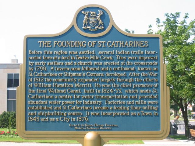


Left: Plaque commemorating the founding of St. Catharines, which was first settled in 1798. Top right: Marritton's factories and mills along the old Welland Canal. Marritton was the second name of the settlement after Shipman's Corners. Bottom right: Old streetcar rail on St. Paul's Street, close to the location of the original Shipman's Corner tavern. Photos: [www.ontarioplaques.com; www.nflibrary.ca].
|
|
SECORD SIGNIFICANCELaura Secord passed through Shipman’s Corner on her historic walk from Queenston to Decew House, St. Catharines. She was travelling with her niece Elizabeth Secord who had joined her at St. David’s but Elizabeth was exhausted at this point and decided to turn back. Laura continued on alone.
|
GENERAL INFORMATION
Shipman’s Corners is the former name of St. Catharines. The city’s origins lie in the rich farmland and waterways, centering on the Twelve Mile Creek and the Welland Canal which was built later.
It was settled around 1798 and was ideally situated for both commerce and settlement. The town centre was located at the crossroads of two native trails and two creeks. The first buildings in town were a simple church and a tavern. Shipman’s Corners was named for Paul Shipman, second owner of the original tavern and operator of a stagecoach stop that was once very popular. The tavern was located on what is now the intersection between Ontario Street and St. Paul Street in St. Catharines, now the approximate centre of the municipality. Since the town was located fairly far inland it was virtually left alone during the War of 1812 while other settlements were destroyed or occupied by opposing armies.
The earliest landowners were Jacob Dittrick and John Hainer, former Butler’s Rangers who, in the early 1780s, settled on opposite sides of the Twelve Mile Creek. Hainer and Dittrick Streets have been named after them. Another notable resident was Loyalist William May, a member of the Indian Department and private in Butler’s Rangers. He arrived on his 350 acre land grant in the township in 1784 and lived there until 1827. The house and property was transferred through the Clark and Seiler families, and by the 1980s it was one of the oldest buildings in St. Catharines and the province. Unfortunately the house was burnt down in 1984, destroying the attempts to preserve and restore the historic building. Roads and other permanent infrastructure were slowly established as more and more settlers moved into the area. Loyalist pioneers were mostly from New York State and Pennsylvania, with some from New Jersey and the New England States. Many were experienced farmers, merchants and craftsmen.
St. Catharines was not a planned out community; individuals had to take it upon themselves to set aside land for schools and churches. Development began as mills were built along the Twelve Mile Creek. In 1815 the village began to expand rapidly. This was due to the efforts of businessman William Hamilton Merritt who built several lumber and grist mills and expanding the salt springs. The salt springs gave the town a reputation as a health spa later in the century, drawing a good number of visitors. Merritt developed plans for the Welland Canal, a close copy of the Erie Canal System down in the United States. The Canals brought more people and business into the booming village. In 1845 the village was incorporated into a town then received city status in 1876. It was officially named St. Catharines in 1808. Today the city contains over 30% of the population in the Regional Municipality of Niagara.
Photo Gallery
Hours of Operation
Street Address. Open Access
DIRECTIONS
From Toronto:
1. Head south on QEW toward Niagara/East Hamilton/Fort Erie.
2. Take the Ontario Street/Regional Road 42 exit
3. Drive 350 m then turn right onto Ontario St/Regional Rd 42 (signs for Regional Road 42 S/Ontario Street)
4. After 3.3 km you have reached your destination. The St. Paul St and Ontario St intersection was the site of the original mill and the centre of Shipman's Corners.
From Niagara:
1. Head north on Queen Elizabeth Way
2. Drive 12 km then take the exit toward Regional Road 48/Niagara Street/Regional Road 77/Welland Avenue
3. Merge onto Dieppe Rd
4. Slight left onto Welland Ave/Regional Rd 77
5. After 1.5 km turn left onto Geneva St/Regional Rd 46
6. Slight right onto St Paul St
7. After 900 m you have reached your destination. The St. Paul St and Ontario St intersection was the site of the original mill and the centre of Shipman's Corners.
Further Information
History of the City. (2013). Retrieved from http://www.stcatharines.ca/en/governin/HistoryOfTheCity.asp
St. Catharines: Description of the Garden City. (n.d.). Retrieved from http://www.herontrips.com/StCatharines.html
More information about St. Catharines
Share this post


Address
St. Paul St and Ontario StL2R 3M2 Municipality St. Catharines
GPS Co-ordinates
Longitude -79.245758


