

- Walk2014
- LearnHistory • Heritage

- TrailMaps • Guides


- ExploreDestinations • Tours • Routes
- NewsCurrent • Archived
News about Friends of Laura Secord

Videos
Print and Online Articles
Blogs
Newsletters - EventsUpcoming • Current • Past
Events

- SupportJoin • Donate • Volunteer
Help support Friends of Laura Secord!


|
Add this location to my itinerary |
The Village of Homer~11 Queenston St, St. David's Ontario L0S 1P0
|
TRIP CLIP AUDIO - THE VILLAGE OF HOMER
Click to play or download THE VILLAGE OF HOMER TripClip (mp3 format).


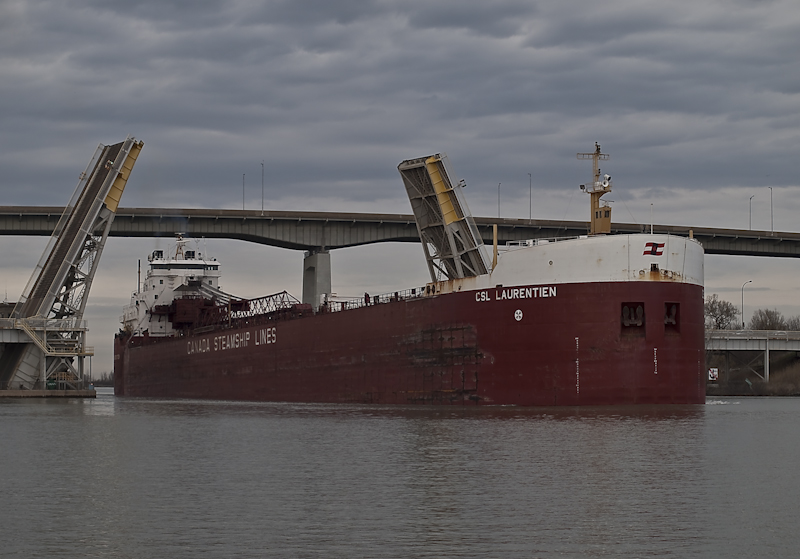
Left: Aerial View of Homer. Note the bridge located at the centre of the photograph. Top right: Map of the land plots surrounding the Village of Homer. Bottom right: Boat passing through Homer Lift Bridge. Photos: [http://www.nflibrary.ca/nfplindex/show.asp?id=99176&b=1; exploreniagara.com; http://www.bigships.net/wpcontent/uploads/2012/04/CSLlaurentien.jpg].
|
|
SECORD SIGNIFICANCELaura Secord passed through the Village of Homer on her historic walk from Queenston to St. Catharines. At the time of her walk Homer was still a small town with only a few shops and houses.
|
GENERAL INFORMATION
The Town of Homer is a very interesting illustration of how transportation has evolved in the Niagara Region over the past 200 years. Previously known as The Upper Ten (as in Ten Mile Creek), the Village of Homer is located in the Township of Lincoln in the shadow of the Garden City Skyway on the QEW in St. Catharines. It was first settled in 1795 by Loyalist William Read and stretched about a mile east and west of Ten Mile Creek along Queenston Road. Back in the 1800s it was an important stagecoach stop and came to feature one store, a school, several hotels and restaurants, and a racetrack. For a time the racetrack was popular, drawing horse racers from around Niagara but it has since been replaced by tracks more central to St. Catharines and other nearby cities.
When the third Welland Canal was constructed in 1931 the town was cut in half, with many of the houses and historic buildings being removed. Business picked up while the QEW was being constructed in 1939 but nearly disappeared when the Skyway was finally completed. Much of the town has disappeared except for the Homer Lift Bridge with crosses the Welland Canal just south of the Skyway, a few houses, St. George’s Anglican Church and the original cemetery. Each of the improving modes of transportation and their routes took from the business and population of Homer because of the town’s location and higher level decisions about how best to develop the region.
One of the unfortunate results of these developments is that Homer Cemetery has been badly neglected, with overgrown, obscured and fallen tombstones. Memorials were installed in the 1930s but visitation is limited, a sad occurrence because of the actual importance of the cemetery. The graveyard holds the gravels of several of the first settlers west of the Niagara River, members of Butler’s Rangers (Loyalists who fought for Great Britain during the Revolutionary War) and numerous veterans of the War of 1812. The oldest tombstone belongs to William Havens, who lived from 1738 to 1800.
Although it has in many ways been forgotten, Homer is remembered as having been on the route of Laura Secord as she walked from Queenston to Decew House, St. Catharines to warn the British troops of an American attack. Before the Forth Welland Canal and the QEW Garden City Skyway were built the old Highway 8 crossed through Homer and over Ten Mile Creek via an old bridge, now rebuilt as the Homer Lift Bridge. This would have been about the halfway point for her historic walk.
Photo Gallery


Airport Inn, Homer Airport Inn Guesthouses Homer Lift Bridge in use
DIRECTIONS
From Toronto:
1. Get on QEW (Queen Elizabeth Way/ON-403) W. Follow signs for Niagara/East Hamilton/Fort Erie
2. Take the Regional Rd 89/Glendale Avenue S exit
3. Merge onto Glendale Avenue/Regional Rd 89
4. Turn right on Taylor Rd/Regional Rd 70
5. Turn left on Queenston St
From Niagara:
1. Take QEW (Queen Elizabeth Way) towards Toronto
2. Take the Regional Rd 89/Glendale Avenue S exit toward Niagara on the Lake
3. Turn right onto Glendale Avenue/Regional Rd 89
4. Turn left on York Rd (signs for Virgil/Niagara on the Lake)
5. Continue onto Queenston St
Further Information
Homer, Ontario. See http://www.ghosttowns.com/canada/ontario/homer.html
Homer Cemetery: Historical and Neglected. (2012). See http://stalkingdeadpeople.blogspot.ca/2012/11/homer-cemetery-historical-and-neglected.html
The Villages of Niagara on the Lake. (2012). See http://memoriesofniagara.wordpress.com/niagara-on-the-lake/
The Village of Homer, Niagara on the Lake, Ontario. See http://www.exploringniagara.com/places_to_explore/forgotten_places/homer.html
Share this post


Address
~11 Queenston St, St. David'sL0S 1P0 Municipality St. Catharines
GPS Co-ordinates
Longitude -79.192457


